Our world’s operations are highly dependent on energy resources. The solar industry is growing at a faster pace. Regular inspection is very important to minimize power loss and to maintain performance because solar panels are subject to manufacturing defects and damages.
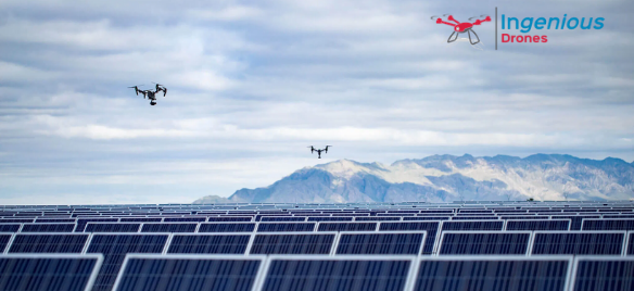
Solar panels typically require very large installations, so it is challenging to inspect the whole area via ground-based techniques. A well-equipped drone with a thermal camera can inspect a solar panel with higher speed and accuracy.
Aerial inspection by drones captures in-depth defects which help to minimize maintenance cost and maximize the output of solar panels. Drones can be used for installing, maintaining, and inspecting a solar panel. Let’s discuss some of the benefits of drone surveying for your next installation.
Installing Solar Panels with Aerial Mapping-
Before installing the solar panels, a drone survey is done to analyze which areas are going to be in sunlight. After the survey 3D simulations are made which will show the impact of the solar panels on the surrounding environment. This gives an accurate image of the efficiency of your solar installation.
Traditionally, solar surveys are done with the help of planes and helicopters which are far more dangerous. Drone surveys are safe because they are unmanned. 3D surveys are used to avoid damage to the surrounding damage. Now many companies offer end-to-end management for data collection, analyzing data, etc. immediately after drone deployment.
Maintaining Solar Panels After Installation-
After the installation drones are used to conduct surveys to identify potential issues. With drones, video feedback can be easily taken and it encourages regular maintenance and it will easy for the technicians to know exactly where and when they’re being deployed.
Completing Routine Solar Panel Inspections-
Solar drone inspection is used to detect the issues especially the heat-related issues. If there is any issue like heat or cracks forming, then the drone reports the exact location of the issue, and it will easy for the technicians to fix that issue.
Aerial Mapping is used for remotely captured pictures and videos and allows drones to capture accurate areas to understand and detect issues and fix them on time. Ingenious Drones Texas provides professional services, contact us today to discuss more.
Recent Comments